

Voyage Around the World on the Frigate La Vénus, during the years 1836-1839
Abel du Petit-Thouars
The Galápagos chapters, translated from the French by K. Thalia Grant, with corrections by Anne Guézou. Bracketed xxx indicates pagination of original French edition. A “†” in the text indicates a footnote, which immediately follows the paragraph in which the symbol appears. Spelling of island names, use of italics and accents follows style of original text.
The author gives the coordinates of five Galápagos islands, with longitudes stated as west (†), or west of Paris (‡). All are assumed to be west of Paris in the table below. These are followed by; a longitude conversion to the Greenwich equivalent (du Petit's value less 2° 20' 00" — Paris meridian east of Greenwich), the actual longitude, the error in du Petit-Thouars' reckoning, and the approximate equivalent in miles. Latitudes are within 5' of actual position, so no corrections are seen in the table.
| Island Name (Official Name) | Latitude (North) | Longitude (West) | ||||
|---|---|---|---|---|---|---|
| from Paris | Greenwich | Actual | Error | in miles | ||
| Bindloes ‡ (Marchena) | 0° 21' 20" | 92° 52' 33" | 90° 32' 33" | 90° 29' 00" | 00° 03' 00" | 4 |
| Culpepers † (Darwin) | 1° 41' 10" | 94° 21' 00" | 92° 20' 00" | 92° 00' 00" | 00° 20' 00" | 23 |
| Dower † (Genovesa) | 0° 19' 30" | 91° 19' 33" | 88° 59' 33" | 89° 58' 00" | 00° 58' 27" | 66 |
| Ronde ‡ (Roca Redonda) | 0° 19' 00" | 94° 00' 23" | 91° 40' 23" | 9l° 39' 00" | 00° 01' 33" | 4 |
| Wénams ‡ (Wolf) | 1° 24' 00" | 94° 11' 23" | 92° 51' 23" | 91° 49' 00" | 0l° 02' 23" | 72 |
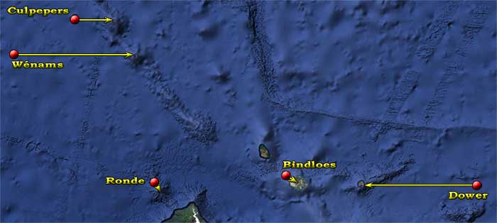
Thouars' coordinates (red bullets), with arrows pointing to actual locations.
[279]
Chapter XIV
Arrival of the Vénus to the Galápagos Islands.—Colony of Floriana.—Its population.—Its productions.—Fitz-Patrick.—Islands: Hood, Chatam, Barington, Porter, Dower, Bindloes, James or Santiago, Abington, Wénams, Culpepers, Redondo, Albemarle and Narborough.
On June 21, at six in the morning, four days after our departure from Peru, we discovered land in the N. W. ¼ W.: it was Hood Island which we saw, it was difficult to see and presented itself under the appearance of three little islets; we were then at a distance of about 30 miles. Little by little, in approaching, the parts of the island, then drowned, appeared successively and soon the islets, by uniting at the base, formed one and the same land.
[280] Hood Island is small and at the very most of medium elevation; from its principal summit the land descends in elongated terraces towards both ends, in a general direction of S. E. to N. W.; however, in the eastern part of the island one saw a little hillock more elevated than the coast, which formed a second summit; one could see yet a third situated inland and more towards the North. This island was covered in vegetation, in the middle of which trees could be distinguished, in general low and stunted, but which, however, in some parts appeared more numerous and of a prettier appearance; this vegetation, in effect, was composed of shrubs mixed with tree-like plants and several varieties of cactus. The South coast has little relief on the shore, following almost everywhere, in escarpment and elevation, the shape of the land of the island. The sea broke with force all along this coast from the S. E. point as far as that of the W., which is the lowest and seems to extend under water for a quite a long distance; a surf, which breaks beyond this point and can always be seen, gives it a dangerous appearance.
At about 8 in the morning, from when we began to clearly make out Hood Island, we noticed Chatam Island in the North: the outline of the coast and its contours were still faint, however the high mountain that dominates the S. E. point of this island was quite distinct. At midday we were about four and a half miles or five miles at the most [281] to the South of the eastern point of Hood Island, from where we noted its East extremity bearing North 4° East; the part of the shore closest to us was about three and a half or four miles distant. At the same time we discovered, from high on the mast, Charles Island and Gardner Islet, but one could not yet distinguish anything due to the distance. We sounded the moment we recorded the latitude and did not find a bottom in 200 fathoms. At one twenty-five we recorded the western point of Hood Island at North 4° East, we paused to make observations and notes: we were at this time four miles at the most from the nearest part of the coast, which was aligned with the highest summit of Hood, and we found, in sounding, 130 fathoms of water over a bottom of fine red sand mixed with fragments of shells; already from the bridge of the frigate one easily distinguished the island of Gardner and the summits of the mountains of Charles Island.†
† Today named Floriana Island.
In the morning of the 22nd, at eight thirty, we recorded the summit of Gardner Island due N.; we then determined the longitude and sounded while making the observations, but without having a bottom in 200 fathoms; we then continued on our way along the South of Charles Island.
Gardner Island is a large islet in the shape of [282] a hay stack, a bit crushed towards the East, which can easily be seen from a point West of Hood Island, that is to say from about 30 miles; it is covered with a lush vegetation. Close to Gardner Islet, and in the West of its position, one sees a large white and barren rock, of medium elevation, whose coast is bold and the top flat. This rock is broken through towards its eastern extremity in the shape of a bridge's arch; the direction of the vault is situated North to South. It is said that in the East ½ South of the eastern point of Gardner, and at about one or two miles distance, there is a rock under water, which breaks in bad weather. From the summit of Gardner Island, from where we have searched to find it, we have never been able to see it; the sea was then too calm, this rock did not break and without doubt it is too far away or too deep under the water for the mark that it must occasionally make on the sea to be seen at the distance where we were.
At midday on the same day, the Vénus was in line, in a more or less East to West direction, with the southern part of Charles Island and a little to the West of its most western point. In this position we did not have a bottom in 200 fathoms. At 10 minutes past noon we continued to make way and headed for the anchorage of Black Beach, where we dropped anchor towards 2 o'clock, more or less in the West of the only house which exists close to the cove of black sand, where one must disembark, and at about two thirds of a mile from the beach, in 21 fathoms of water over a bottom of fine red and black sand, scattered with rocks. [283]
Charles Island is much more mountainous than that of Hood, it is also much higher; the very uneven terrain, the mountains with rounded peaks, serve for its recognition and prevent it being confused with that of Hood. In any case, Gardner Island that one sees at about three miles in the East of its position, would get rid of any uncertainty, if there was any doubt as to its recognition.
At the southern point of Charles Island one sees a little rock raised above water whose distance from the land is at most a cable's length; all the coast of the South is bold and bordered by deep waters, but everywhere the sea breaks frequently on the shore. Charles Island is covered in a rich vegetation, which spreads from its summit to the edges of the sea, and it is wooded in several parts. Among the plants that one sees on this island, one particularly notices the different species of cactus and a tree, taller than the others and ordinarily without leaves, which is very common there. These leafless trees appear dead and whitened or dried by the sun. All the voyagers who have visited the Galápagos Islands, struck by this aspect, have affirmed, without having verified the fact, that these trees were dead; however, they are not; they only have that appearance which comes from their absence of leaves. From the fact that these trees were without leaves, in a place where generally trees keep their leaves year round, one naturally had to suppose that they had ceased to live.
In the cove of Black Beach we met a [284] little schooner under the flag of the Republic of Ecuador† she was commandeered by M. Lawson,§ lieutenant of a navy vessel of this State. M. Lawson, officer of an energetic character, who had often been in interim charge of the governing of Floriana, is a bright and clever sailor; he hastened aboard to offer his services; and he has been a useful help to us, as much for the nautical information that we have received about this archipelago, as for the interesting information that he has given us on the occupation of these islands by the government of the Republic of Ecuador; on the establishment of the new colony on Charles Island; on the different productions of this island; on the fertility of its soil, the possibility of expanding the cultivations already started and in forming new ones; and, lastly, on the climate, the reigning winds, and all that can be of interest, whether for the sciences or for navigation.
† Written as Republic of the Equator in the original text.
§ M. (Monsieur) Nicholas Lawson.
In my stopping in the cove of Black Beach, which in reality is just an anchorage on an open coast, my plan was only to know it. From the 23rd we recommenced under sail, and went to anchor in the bay of the Poste†, where we arrived about [285] four o'clock in the afternoon. At this anchorage there was the American whaler Augusta, in port to take on provisions and wood. We occupied ourselves, from that same evening, in the establishment of our observatory. The beach was not amenable to this operation, as everywhere the coast is bordered by loose piles of lava rocks, which form a shifting, uneven, rugged ground and very difficult to walk upon. Further inland, the terrain is not better and is, besides, covered almost entirely in several species of cactus, of spiny shrubs and tree-like plants which prevent penetration into the island without first clearing a way with an axe. During our stay in this cove, the length of which was determined by the time necessary for the magnetic observations, we sounded the bay and I visited the eastern part of Charles Island in hopes of discovering the under water rocks that are said to exist at the N.E. point of this island and to assure myself of the existence of that believed to be situated East ½ South of Gardner Islet. We first acknowledged, by our research, that the rocks placed on several charts to the point N.E. of Charles Island don't exist where they are placed; and the assurance of their non-existence in any other part of this island, assurance which, already I have had given to me by [286] a bright sailor which I had met in Payta, has lastly been confirmed to me by M. Lawson; but, these two sailors have also certified to have seen the rock situated to the East ½ South of Gardner breaking and have recognized Cowan reef to the point N. W. of Hood Island.
† Post Office Bay, name given by whalers before the island was inhabited; they took care, when they put into port there, to leave in a bottle, buried or hidden near a tree on which they made a noticeable mark, a note which ordinarily told the name of their boat, of the captain and the number of barrels of oil already taken; it was a way for the whalers to send their news to the United States, as the vessels whose fishing was finished would never fail, before their departure, to touch at this island to take on a supply of tortoises.
The day of June 26, captain Lawson, whose schooner had changed anchorage in the same time as the Vénus, came to join me on board, and we left straight away to go to Black Beach and from there to visit the settlement of Floriana. We left the frigate at 6 in the morning and we arrived at Black Beach at about 8 o'clock. We had some trouble in disembarking as the sea broke very high on the coast and without the help of the inhabitants who awaited us, it would have been difficult to put the whaler high enough on the shore to avoid being broken over.
We found at the landing house a gathering of a fair number of inhabitants who had come to meet us: they surrounded us and welcomed us with kindly demonstrations. Shortly after our landing we left, mounted on asses that had been brought for us, and we traveled forth peacefully to the settlement situated at about one and a third miles from the coast near to the first spring. We proceeded up to this station on a rocky path whose gradient, at first gentle enough, wound in climbing through a thriving vegetation that bordered the sides of the path and did not reach higher than under four or five meters; this [287] vegetation is composed of shrubs and perennial plants, which in general and with few exceptions showed us a new aspect. Along the way, M. Lawson showed me the plants that were useful, whose use is most widespread among the inhabitants. In this way he made known to me a shrub, whose aromatic leaves are used in an infusion, like tea, whose place it takes; the American whalers, lacking the other, made equal use of it; this drink is furthermore of a pleasant flavor and very healthy. M. Lawson directed my attention back to the tree about which I have already spoken; it is the largest of all; it rises five or six meters above the ground and is very common in the island; it did not then have leaves and its bark, of a whitened color, made me take it to be a dead tree burnt by the sun. Captain Porter, of the navy of the United States, and captain Fitz-Roy of the English navy, in having judged it in the same manner left me in a great uncertainty about the subject, despite the contrary opinion that I had heard up until now. To find out, we walked to one of these trees, and in making an incision in the bark it immediately gave out a white, strongly aromatic sap; this liquor is a balm which has been used with success for all sorts of wounds, and the bark of the tree is usefully employed by the inhabitants, in applications in the dressing of wounds. To collect this balm it suffices to make an incision in the bark as we had done, but the season of sap is [288] the best time to collect it and this is when it is done.
Arriving at the first village, we found ourselves just about 300 meters above the level of the sea, the view that we had from there was magnificent. At our feet we viewed all the coast that extends from Saddle Point as far as Dismal rocks,§ situated at the East point of Post Office bay. It was about one third the extent of the entire coast of the island; the rest was hidden by the topography of the mountains which dominated us to the E; from there, also, we saw the frigate which lay majestically in the harbor of Post Office Bay, where she seemed to be resting, and we saw the whaler Augusta, anchored next to her, set sail and head towards James Island. The horizon was then very clear, we could see all around, in the W. N. W. the southern point of Albemarle Island; more to the North than this point we distinguished more easily the islets situated in the E. S. E. part of this island, and, in the North James Island, recently named Santiago by the settlers of Floriana,§§ showed itself; finally still further East one saw part of the island named Indefatigable or Porter and absolutely in the East of our position the view was, as we have said, limited by the mountains which spread on one side towards the North point of the island and, on the other side, towards that of the S. W. In the E. S. E. we had the large summit of the island whose peak was, at this moment, covered in cloud.
§ The author apparently had read David Porter's Journal of a Cruise, in which he named Rock Dismal (now Corona del Diablo).
§§ Actually, Santiago was applied to Norfolk [the modern Isla Santa Cruz] by Antonio de Alcedo in 1786. The Floreana settlers may have been familiar with Alcedo, but mistakenly thought he meant James [San Salvador], not Norfolk.
The village where we stopped is to this day only known [289] by the name of the first spring; it is composed of eight to ten huts which were formerly inhabited, but only two or three were currently occupied. The inhabitants came to us; several asked me to authorize the missionaries that we had on board to land in order to baptize their children; I promised to have these men attend to their wishes, then we continued heading towards the main settlement.
In leaving this station the way is much steeper, and one notices the vegetation becomes more and more lush in step with advancing; we were on each side surrounded by trees seven or eight meters in height, which gave us shelter from the sun and rendered the route very pleasant for the coolness which it gave us; on our left we had a ravine masked by trees; on our right was the great summit of the island around which we were climbing. In the East of this mountain a great fertile valley suddenly unfolded itself before our eyes; we saw, then, huts spread out and surrounded by banana plantations, fields of corn, manioc, sugar cane, potatoes and vegetables of all types; these huts were separated from each other by groves of trees or by the beginnings of the clearings. It is in this valley that the new habitants have found recompense for their work, as much in the abundance as in the variety of crops that they have obtained. The banana tree, like all the trees [290] imported by the settlers, grow very well there; the papaya trees have become very beautiful there, but they have not yet carried fruit, which was a cause of great surprise to the inhabitants, as they flower every year; this sterility is probably due to the fact that these trees are, like the almond trees, of two sexes and that so far only one gender was found on this island, which prevented them from becoming fecund and producing; the orange trees there were also of a lovely appearance, and were equally barren, without doubt also for the same reason; as a sort of proof the lemon trees and pomegranate trees have yielded fruit in abundance, and the fig trees have also given a profusion of excellent figs; these trees are, to this day, the only useful trees that have been naturalized. The attempts at coconut palm plantations which have been made have not been successful as of now, probably because the inhabitants, instead of planting them in the lowest lands and near the edge of the sea where in general these trees do very well, they have planted them, believing they would fare better, in the higher basin of the island where the vegetable mold is more abundant and of an excellent quality, it is true, but where the humidity is constant and where the sun, often hiding behind the mists which surround the peaks of the island, shows itself rarely.
The native trees of the Galápagos Islands offer 12 or 15 varieties; the largest are those that produce [291] the balm; among the others one notices many species of laurel, of carob, and other unknown varieties. The wood which one finds in the Galápagos Islands is not of large dimension and is not suitable for carpentry, but it is perfectly suited for the construction of houses such as those established. Three species of cactus are very common on this island; that which is composed of flat leaves in the shape of rackets reaching an extravagant thickness: the trunk is sometimes 50 centimeters in diameter and two to three meters in height, the fruit which it produces adheres immediately to the leaf and is of an indifferent flavor; this species is extremely common on the northern coasts of Africa. A second variety is formed of long round parts, about 60 to 80 centimeters each, which are stacked one on top of the other; it gives a red-purple fruit which look like fat plums. This fruit is filled inside with a soft white substance, mixed with infinite little black seeds, like in the fig; the taste is very pleasant and a little bitter: it recalls to mind that of our fat gooseberries. This variety is, I believe, that which the English refer to more particularly by the name Prickly pear. The third species is very common on the continent of America; it is formed of parts long and fluted like candles. The shrub which produces cotton has been found in the lowest parts of the island and half way up the slope, in lands which are, in appearance, the least fertile and [292] the most dry. This discovery has given place to the importation of the best species of cotton from Guayaquil, which have been transplanted in the higher valley and half way up the slope close to the first spring; these localities have been preferred for the same reason which induced the inhabitants to plant the coconut palms there. These attempts with the cotton plants had much better success in the latter place than in the part that at first seemed the most fertile. Near the first spring the cotton plants have given pods well filled with lovely cotton, very white and with long threads, whereas in the valley they have done poorly. The inhabitants attribute this difference in result to the very great humidity of the valley which, situated between the two highest peaks of the island, is almost always covered in cloud, and too exposed to frequent showers, the effects of which rarely spread to the lower parts and to the coast. We have noticed in these islands that which we have frequently observed in the Sandwich Islands; that while it rained very hard on the mountains, standing at their feet and to the leeward, we did not receive a single drop of rain. One cannot doubt that if one does not find water on most of the Galápagos Islands, it is because the very permeable nature of the ground which, in general, is composed of loose lava rocks, of scorias and of volcanic cinders, absorbs all that falls, and thus prevents the flow of water to the shore.
However, one can expect that in the [293] near or distant future, this drawback will disappear completely. This will probably happen when the plants, by their successive decomposition, have formed enough vegetable mold for the different parts of the ground to compress, so that it ceases to be permeable. Already today in the valley of Floriana where the vegetable mold is deeper, one can, in several places, procure water by digging. In a gorge, situated to the East of the mountain which protects the valley in this wind direction, one finds a lake which rarely dries and whose waters, in the rainy season, are poured towards the E. S. E. coast, but they do not reach as far as the shore, the terrain not yet being compact enough.
In examining with attention the Galápagos Islands, in general, and each of them in particular, one notices that the highest parts of these islands are the most fertile; that the vegetable mold there is deepest; that it retains the coolness better, and that in descending towards the shore, the layers of earth are less thick and more rare; that this decrease of soil is accompanied by a similar decrease in the vegetation; lastly, one notices that in descending from the summit towards the coasts, the same plants become less green and the trees more stunted. It is to the point that, on many of these islands, the vegetation stops almost entirely before arriving to the edge of the sea; that on most of them there is yet nothing at the shore, not even a blade of grass. There the ground, composed only of [294] volcanic rocks and scoria, shows itself bare, black and barren and even at low tide, one does not find a marine plant, not even a Fucus [seaweed] on the beach.
On some of the Galápagos Islands the summits, or only some parts of the summits, offer traces of vegetation; in the others the vegetation is more advanced and descends as far as a third or half way to the coast; and even as far as the shore. On the islands that seem to be most recently formed, the vegetation shows only on the peaks and on some isolated parts, where it forms types of oases, which contrast by their coolness with the burnt and black aspect of the terrain surrounding them.
As a result of these observations it seems that on the recently formed volcanic lands the vegetation starts by taking hold at the summits where a constant humidity, owed to the effect of condensation acting on the air, gives rise to an initial decomposition of the ground, and in some way to the creation of a silt that suffices to give birth to a pioneer vegetation, which, little by little, increases and extends downwards at the same rate that the plants, by their repeated decay, form a vegetable mold which allows these plants to grow successively more mature and more vigorous. From whence it follows that the most fertile islands have necessarily to be the most ancient, and vice versa.
After all which precedes, one sees that it would be easy to classify the Galápagos Islands by their age, if however one could not presume, and with reason, [295] that a greater elevation of mountains, principally with a very great humidity, was not a cause of acceleration in the growth of the vegetation, and of the happy consequences that it brings. It would be very interesting, however, to know, at this given degree of latitude, how much time is needed to convert a shapeless and sterile mass of volcanic rock and scoria into a fertile and watered terrain. Would it not be possible, by making some reliable observations, to obtain an answer to this problem?
If the first navigators that visited the Galápagos Islands had truly looked well there was no water anywhere on these islands at the time of their discovery; and still later, in a more recent period, that of the cruise of the United States frigate Essex, in 1813, did not find but one source, on the island of Floriana. Commander Porter, however, passed close to Chatam Island and did not see the two cascades which, at the S. E. point of this island fall to the sea: he needed water, and it certainly suited his interests to look well! Is it that these cascades did not yet exist and that the terrain had later become more compact, permitting today the flow of waters which, perhaps in this era, were entirely absorbed before reaching the shore? The ignorance of this fact by all the English whalers that he had made prisoner would lead us to believe it. But let us return to Floriana.
After having examined for some time the picture [296] before us, we began to descend into the valley; passing on our left some chacras [small farms], we stopped at the first hut that we found on our right; situated on a small hillock, it dominates the valley and the view that one has from this point unfolds pleasantly. This residence belonged to a young man named Para * who, at that time, filled the functions of governor: he received us with warm politeness, and his wife did her best to give us the benefit of the honors of her house, the arrangement and cleanliness of which were its praise, but whose extreme simplicity does not require any particular description. In the company of the governor we walked on foot towards a large two-story house of better appearance and situated in the eastern part of the valley, at the foot of the mountain which limits it on one side; this residence is the largest of the settlement, and it seems that, by its position, it should be, one day, the center of the capital to come. This house was in the past the property and residence of the governor M. don Jose Willamil [sic, Villamil]. It was now occupied by a lady and her two sisters; this lady, wife of an officer of Guayaquil, exiled following an attempted revolution in which he declared himself general, had accompanied her husband in his retreat, and she was esteemed by the inhabitants, by whom she was also well liked, as she gave example of all virtues, and above all, that of resignation to her bad fortune. She lived there, very isolated, surrounded only by [297] her sisters and by two pretty little girls who were her only consolation, as her husband lived on James Island where he took care of an industrial enterprise. He hunted tortoises in order to extract their oil; this product, much sought-after, has great commercial value and is used in cooking, in preference to lard and beef fat of general use, on the neighboring continent.
* Perhaps in José Villamil's absence, Sr. Para functioned as governor when Captain Lawson was at sea.
This very productive industry has unfortunately brought about the almost complete destruction of the tortoises with which these island abounded; they offered a very precious food supply for the whalers. There was not a ship which, in its passage through the Galápagos Islands, had not taken in provisions up to two or three hundred of them; they kept perfectly in the ship's holds for between one year and eighteen months, without needing care and without giving them food. The journal of Captain Porter says that after such a lapse of time they did not appear to have suffered and, to the contrary, were better. The same journal also tells us that there were those that weighed three to four hundred kilograms. Those one finds now are already very rare and their weight ranges only from 5 to 50 kilograms at the most. One assumes, however, that the tortoises are still very plentiful on the islands of Albemarle, Chatam and Hood. The inhabitants of Floriana, judging from the small amount that the tortoises grow from one [298] year to the next, indicating that these animals are a great number of years before reaching full size, imagine that they live for a hundred or hundreds of years.
We received a gracious welcome in the house of las señoritas†, as the whole population calls them: they offered us a very good meal composed solely of productions from Floriana; in place of bread they served us flat cakes made with corn flour. After having enjoyed for some time this lovely and pleasant reception, we strolled around the surroundings of this house and looked at a grotto in which clear water flowed from the rock into a little basin cut to collect it, and from where it then escapes, after it has filled, to be lost somewhere in the spongy ground around it; we collected in this fountain several shells of a family of fresh water snails. Next to this spring whose water is not abundant, but sufficient, however, for the consumption of all the inhabitants, we noticed ovens hollowed out in the rock of the mountain, just like those which one sees on the banks of the Loire, dug in the tuff of the hills. Not far from these ovens we visited a type of shallow cave, which is said to have been the residence of Fitz-Patrick [sic, Patrick Watkins] and his companions.
† The young ladies.
Pressed by the time, we took leave of our hosts, then we returned to the house of the [299] governor where we had left our things. In crossing the valley a second time, the numerous showers that had fallen during our excursion, had rendered the terrain slick and the walk difficult: nonetheless, one raptured over the beauty of the day that we had chosen, which makes one think that the rains there are very frequent in this season of the year. We arrived swiftly at the beach, where we embarked straight away, and already it was night by the time we returned to the frigate.
In returning from the settlement of Floriana to the beach, we noticed that from the first spring to the shore, not one drop of rain fell: the rain was concentrated in the valley; the temperature, always pleasant and often cool in the upper basin of the island, became at times insufferable by the excessive heat that one felt in descending towards the coast: the difference in temperature from the summit of the island to the shore is always at least 3 to 4 degrees.
The Galápagos Islands, situated exactly under the equator, have, strictly speaking, but two seasons, which one divides into dry and rainy, or to be exact, two winters and two summers. Each time that the sun passes the equator, the weather is very stormy and squally; the rains are abundant and very frequent. In the interval between squalls, the weather is calm, heavy and the heat excessive, however the climate is always healthy; no sickness has manifested since the establishment of the colony.
[300] When the sun is at the equator, the winds are more variable; then they blow sometimes from the N. W. and the West, but while they come from these directions they are never very strong; only the mists are frequent.
In the fair season, that is to say, while the sun is towards the tropics, the trade winds are fresher; they blow more from the South when the sun is at the tropic of Capricorn and more from the North when it is to that of cancer. While, in these latter seasons, the winds blow from the West or the N. W., they are short and always weak: the strongest winds blow ordinarily from between the S. S. E. and the S. S. W., but it is rare that they oblige one to have more than two reefs in the topsails.
While the sun is in the tropics, the weather is very nice; the temperature is always high, but pleasant, refreshed by the constant breezes that then dominate.
During our stroll in the valley of Floriana, we frequently entered the huts of the inhabitants; everywhere we have been received with welcome, being offered salad, melons and milk; but everywhere it seemed to me that the inhabitants, although comfortably enough established, appeared to acutely desire to return to the continent: they seemed to consider themselves temporary inhabitants.
I presume that one of the main reasons for the feeling of estrangement of the settlers for this settlement arises from [301] the mistake that had been made, of mixing among them depraved people regarded as the dregs of society: the fear of being confused with them is not the least of the reasons for their discontent. It also seems to me that men used to activity and to the bustle of large towns, are the least suitable to found a colony and the least disposed to take on the habits of rural life; they are little capable of appreciating the quietness, the activity in which they lived is a need and like an indispensable element of their existence.
Most of the mountains of Charles Island show traces, more or less sure, of the existence of volcanoes: the nature of their ground and their summits sunk in the interior leave no doubt in this regard. Active volcanoes still exist today on the islands of Albemarle and Narborough; even more recently, in 1836, there have been several successive eruptions and since then they seem to always smoke.
The earthquakes, that terrible curse of the continent of America, are not known to the Galápagos Islands; at least since these islands are occupied, one has never felt any tremor.
Before the arrival of the settlers, the Galápagos Islands did not posses but a very small number of animals; among the quadrupeds, one counted only the land tortoises, which reached a phenomenal size; the red and gray lizards, and another species which appears amphibious; this last species is much larger than the [302] first two, it is black on the back, yellow under the belly, and from the head to the tail is armed along the back with a row of spines in the shape of a saw: this variety is hideous to look at and is not found on the continent; it however, distantly resembles the iguanas of the river of Guayaquil. The rat was also one of the inhabitants of the Galápagos, but it is not certain that it had not been introduced by the ships which, over different periods, have visited this archipelago.
There are few land birds in these islands; one notices among them a very pretty turtledove which is good to eat; a very friendly bird that is called sueño on the coast of Peru; a type of small duck, the water hen; flamingos, egrets and two species of crab-eaters; and among the sea birds one counts several species of gulls, the gray pelican and the frigate bird: the last is known to the English by the name of man-of-war-hawk†: this bird is very common on Gardner Island, where it nests in great numbers; it was not shy and allowed itself to be taken by hand.
† Epervier-vaisseau (literally, ship sparrowhawk).
One finds on the Galápagos Islands only a very small number of insects and only a few butterflies; but one comes across a very large number of yellow-winged grasshoppers and an immense number of scorpions or millipedes, which attain a length of up to 18 or 20 centimeters; their sting is venomous but not dangerous; a species of snake is [303] also quite common; it too is harmless.
Since the occupation of the Galápagos Islands, almost all the domestic animals have been introduced: one counts already one hundred and thirty head of cattle, cows, bulls, beef or veal, some horses, a fair number of asses, several hundred goats, and one estimates the number of hogs over two thousand. Most of the animals are free in the mountains, where they multiply. The sheep, either through lack of care or lack of plants suitable for their nourishment, have not succeeded well: perhaps also the dogs and pigs which have killed many of them, could be the only cause of their failure.
The pastures are abundant enough in the island; one notices, however, that in general, none of the animals fatten, which does not prevent them from being of good quality. The excessive number of dogs that the inhabitants keep under the pretext of their safety, is a veritable calamity for the tortoises, which they kill.
The 27th, in the morning, to keep my word to the inhabitants, I put my boat at the disposal of the apostolic missionaries Devaux and Borgella, and they went to Black Beach and from there to the principal settlement, where they were received with eagerness; they celebrated mass and baptized nine children, the first born on Floriana; they also gave consolation to all, preaching on the forgetting of offenses, the necessity of [304] prayer, and they consecrated as a burial place, some land, in which they blessed the first cross. The missionaries did not return aboard until the next day, happy to have started their ministry in such a way. The government, by the nature of the mission in which we were charged, had put at my disposal different objects of prime necessity, appropriate to be given to new people who yet lacked industry. I found it appropriate to dispose of some of these essentials, such as tools, ceramic pots, and vegetable garden seeds, in favor of this budding colony: I regret only that I was not richer, well persuaded that in this way I could fulfill some of the kindly intentions of the king.
The Galápagos Islands, situated under the equator, at about 160 leagues to the West of the western coasts of South America, extend in longitude from 91° 37'23" to 94° 21'20" to the West of the meridian of Paris: they are contained between the parallels of 1° 42' North and 1° 24'20" South.
This archipelago, composed of thirteen principal islands and of several islets or isolated rocks which neighbor them, are incontestably of volcanic origin; all the islands which are part of it are elevated and can be seen from 10 to 20 leagues in clear weather. The time of their discovery goes back to the first times of the conquest of Mexico and preceded that of Peru, towards which the adventurers to whom one attributes it, planned to head, driven by this fever of ambition, of glory and [305] fortune which gripped the Spaniards of this period, and particularly that group of people from all nations known under the name of buccaneers, a name that they glorified by the more brilliant ways of battling. An expedition devised by these last, leaving from Panama, against the season, to explore the coasts of America towards the South, where they hoped to make important discoveries, were beaten by a storm in the gulf of Panama, and battered by the bad weather and the prolonged and unforeseen impediments which would bring about the ruin of their ships; one party perished at sea, the other party arrived at the Island of Gorgone, situated on the coasts of Choco. Finally several of the crippled vessels cast away from the coast and went to the Galápagos Islands, ignorant of their position and desperate for their safety. These sailors stayed in this archipelago without being able to leave for lack of a ship, which one ensures was the reason for the islands of this group being called Isles Enchantées † a name which they have long been called. Uninhabited before the arrival of the buccaneers, they stayed deserted until a very recent period, where they have begun to be frequented by American and British whalers; these whalers got an abundant catch, and moreover, found for their crew precious resources and provisions in the large number of tortoises with which they were populated, and from whom they [306] have taken the name Galápagos, under which they were also known, and which seems today should be replaced by that of Floriana.
† Islas Encantadas.
These modern explorers found debris from residences of the buccaneers, revealing that they were established on the islands of James and Chatam, two of the most fertile and suitable for a permanent settlement. The bays where they found these vestiges have received, because of them, the name Buccaneers Bay, a name established in the history of the grandeur of the plan conceived by the buccaneers†, the disaster which followed, and their stay in the islands of this archipelago. Since the period when the islands were visited by the whalers for the first time, the great number of whales that they came across brought them back with other whalers whose numbers increased each year until 1834; today this archipelago is much less frequented, the whales have progressively decreased in these localities, either having gone towards other areas, or having been destroyed there. The number of whalers has likewise followed the same declining progression.
† The names buccaneer and filibuster were then synonyms, it is the first of these societies from which the second takes its origin.
Around the first times of the establishment of whale fishery in the Galápagos Islands, a man named Fitz-Patrick, Irish by birth, maltreated and unhappy on the ship where he was embarked, conceived [307] a plan to remain in these islands, a modern Robinson, to live there alone and from his own industry. While his vessel was anchored at Charles Island, he hid, in order to execute his plan, up until the moment of departure, then he worked to make a residence. In a little time, he managed to cultivate potatoes and some edible plants, which gave him the means to trade with the whalers, so that he could procure clothes, brandy and also, to his misfortune, money. In effect, having been imprudent in letting others know about his treasure, some seamen, incited by greed, robbed him, after having beaten and tied him up, and then left him in that state. However, Fitz-Patrick managed to untie himself and swore vengeance. The occasion presented itself shortly. A whaler had come to anchor in the bay, the captain asked him, as was customary, for provisions; Fitz-Patrick was known to all the whalers, by hearsay if not by face; one knew that with his help it was possible to procure some vegetables; Fitz-Patrick promised but asked that they send a whaler to get them, and that the sailors come to his cave to do so. All thus planned, he waited, hidden in the rocks, near the landing stage, for the whaler to land on the beach and for the sailors to leave. Then he left his retreat and broke up the boat in a manner that it could not serve to take them back; he then returned to his residence. The sailors having found no one at the cave, after having searched some time in the [308] vicinity, had returned to the beach; they then saw the impossibility, in which they were, of returning to their ship, and found themselves at the mercy of Fitz-Patrick for their survival. He, being armed, made them work for him and thus became a type of monarch. It is said that his companions grew accustomed to their lot, or rather that, seduced by his promises and the hope of sharing the benefits of his establishment, they consented to stay with him, from when soon followed a new prosperity. However, Fitz-Patrick, often tricked by the whalers, grew disgusted with his position and formed the plan to go to the continent of America. To put into effect this new plan, he took a boat from a whaler and, followed by his men, in number six in all, he left the Galápagos without compass and without means of directing him there; however he made towards the East, guided by the sun, and after endless troubles, that one can easily imagine, since he had to struggle against the winds and currents which generally flow to the West with a speed of 18 to 20 miles in twenty-four hours, Fitz-Patrick landed in the bay of Tumbez, at the mouth of the Guayaquil river. From Tumbez, he went to Payta, where soon his behavior aroused suspicion. He was already married to an Indian woman and talked of returning with her to the Galápagos Islands, when the rumor of his departure from Charles Island, with five sailors, none of whom arrived with him, spread and brought attention to his account. He was finally arrested and taken to the prison of San Miguel de [309] Piùra; after this arrest, no one knows what became of him: one has heard no more of him.
The Galápagos Islands thus found themselves deserted once again, until a short time later, when Fitz-Patrick had a successor in the name Johnson, citizen of Altona, who was followed by a Dutchman: the two had deserted from an English whaling ship, and copying the example given by their predecessors, they devoted themselves to agriculture. Soon after their establishment in Charles Island, they supplied whalers with potatoes, sweet potatoes, pumpkins, melons, etc.
In 1830, Captain Lawson, who had already visited these islands and knew their fertility, and particularly that of Charles Island, brought some domestic animals, such as goats, sheep, pigs to set them free there, in the well-founded hopes of deriving, after a little while, great advantages. He found Johnson established on this island; this impediment did not put him off, however: he entrusted to him all his animals with the one condition that he did not destroy the stock. A little time after this period, in 1831, four people named Fernandez, Villasmil, Garcés and Barck, all distinguished officers of the army of Colombia, proposed to the government of Ecuador to create a fixed settlement in the Galápagos Islands. The government of that time, considering itself sufficiently established in regard to its legal right of possession of these islands, agreed to this proposal which began to be [310] implemented straight away. Charles Island, chosen as the chief place of settlement, received from this moment the name Floriana, name given in honor of general Flores, then president of the republic, and which it kept permanently.
The first expedition, carried out by the four officers mentioned, was composed of twelve to fourteen laborers which voluntarily offered to start this colonization, and also some political criminals, condemned to death, who obtained their pardon, on the condition that they go to live in this settlement. In leaving Guayaquil, the colony headed for Charles Island, where it at first established itself close to the spring that one finds halfway from the coast, at about one and a third miles in the East of Black Beach, at the same place where Johnson was living.
The first three officers that we have already named promptly gave up their plans of colonization and returned to Guayaquil, leaving to Mr. Barck the governing of the settlement. This governor had much to suffer in the beginnings of his enterprise, and after a year of residence, during which he did not receive any help from the mainland, he asked for, and obtained, his replacement. M. Joseph Willamil, a man well distinguished by his education and for his high administrative capabilities, and one of the first companions of general Bolívar in the war that he undertook for the independence of Peru, proposed to the government that he be in charge of the managing of Floriana. The [311] government of Ecuador accepted, with eagerness, the services of a man who assured the success of this settlement, and granted to M. Willamil a charter which gave him great privileges for himself and his descendants.
M. Willamil, confident in the future, arranged to go to Floriana, where he led a new detachment of settlers, composed of some political prisoners, of some volunteers of both sexes and, very unfortunately, also some prisoners who had been locked up as vagabonds leading a bad life; he brought, as well, some of his people, beasts and all that he thought necessary to make an agricultural settlement succeed and prosper. Arriving at Floriana, he explored the whole island with particular care, and soon came to know the fertility of the upper valley, whose lands he distributed to the settlers. Enlivened by his example, all worked actively to build their houses, to clear the land, to plant and, almost without outside help and without any support, the settlement, under his administration, both firm and wise, grew and flourished.
At the end of 1834, the population was 100 inhabitants at the most. In 1835, a new detachment of 37 settlers of both sexes arrived at Floriana: it was very promptly followed by other settlers who arrived in both small and large groups, one shortly after the other.
Until then M. Willamil had worked without stopping at [312] his colonization and had made great sacrifices to introduce to the island stocks of domestic animals that were lacking there; he introduced and naturalized a fair number of asses, some horses and some sheep; afterwards these animals multiplied there. M. Willamil was relieved during 1835 by Mr. Lawson, appointed interim governor; he ran the colony up until the beginning of 1836, time of the return of M. Willamil to Floriana. During this year the inhabitants sold about 7000 piastres worth† of provisions or supplies to the ships that put into port at the Galápagos Islands.
† About 37,500 francs, intrinsic value.
At the end of 1835 the population had already grown to about 350 people, of which more than 150 were soldiers or servicemen exiled for being involved in political movements which had troubled the Republic of Ecuador in the last months of 1834. As soon as peace was reestablished in the state, many of these condemned were pardoned and returned to Guayaquil, thus considerably reducing the number of settlers.
After the return of M. Willamil, in 1836, he took careful charge of the administration and looked to extend the revenues of Floriana by making some attempts at fishing for whale; this industry which he wished to create obliged him to be frequently absent, and was the cause, one assures, of the discussions brought between him [313] and the government of Ecuador which, from then on, its president being different, seemed to dispute some of M. Willamil's privileges, dissidence which obliged this governor to retire momentarily to Peru to battle for his rights and which forced him, eventually, to abandon an enterprise to which success is generally attributed.
Some troubles arose in the colony after the departure of M. Willamil, causing several inhabitants to return to the continent, and the population found itself, again, reduced to less than one hundred settlers. However, several of them who, following this restless spirit which makes one see a good life where one is not, had left their establishments to go back to the continent, later returned there; this fact, very favorable to the settlement, must, I think, make these islands be seen as permanently inhabited.
The Galápagos Islands are thus, to this day an important place for sailors to put into port; they are sure to find provisions in food supplies, in abundant wood, and in water, at Chatam Island, where, however, it is still not easy to do so, the place where one finds it being situated in the windward side of the island, and on the open coast. A ship of commerce may provision at Floriana Island and even at the E. S. E. part on Albemarle; almost all these islands offer, moreover, safe anchorage.
Hood Island, the most southern of the Galápagos Islands, is situated in the S. E. part of this archipelago; it [314] is of medium elevation, and can be seen from 8 to 10 leagues in favorable weather.
The entire coast to the South and the East seem safe, and can be approached, in these directions, up to a mile or two from the shore.
This island is covered with vegetation of a stunted appearance; however one can procure wood there, for burning.
As of today, no one knows of any fresh water source on this island, and as the land is composed of lava rocks and scoria, it is impossible to procure it by digging.
To the North of Hood Island, a little island, a little way from the coast, forms, with the North shore, a fairly good anchorage called Baie du commodore Rogers. This bay is not frequented except by whalers, who come there to rest and take on tortoises, which one still finds in fairly large numbers on this island. In the laying season, sea turtles are also very numerous on the beach of this bay, which is, moreover, full of fish.
In going to anchor at Hood Island, one should not enter the bay to a depth less than 12 fathoms. Further inside there are rocks under water, which would be dangerous if the winds blew from the N. W. or from the West.
At the West point of the island there are some rocks under water, which extend in this direction and always break. Further out and in the N. W. at about 12 or 14 miles, one finds a reef called Cowan, [315] this reef always breaks and has not been explored to this day.
Chatam Island is the most eastern of the Galápagos Islands, and one of the most important for the resources which one finds there; it is very high in its South and S. E. parts; its summit is almost always covered in cloud, and it can be seen from 15 to 18 leagues, in fair weather.
In the North and in the N.E. of Chatam Island the terrain is low and all this area is curious for the multitude of little cones that one sees there, and which, without any doubt, were, in times past, so many craters of volcanoes. This part of the island is barren or almost entirely devoid of vegetation, whereas the part in the South, covered in a beautiful verdure is wooded and watered.
The South coast of Chatam, bold at the shore, seems safe and appears able to be navigated along very close; we have run along it from one or two miles distance, or more, and have not sounded the bottom in 200 fathoms. One knows, nevertheless, that very close to the coast there is a bottom that extends out far enough to offer an anchorage.
There are several harbors to chose on the coasts of this island. One of the best is that of the bay of the Buccaneers, on the N. W. coast; it has however the inconvenience of being in the most barren part of the island. The anchorage of Stephens bay, near to Kicker rock, is also very good; one prefers it generally to all the others, due to its proximity to [316] a water source and for the ease of procuring wood there. The whalers come to this anchorage to water, wood and take the tortoises that are still yet fairly numerous on this island.
No part of Chatam Island is yet inhabited, but it is disposed to be so; it is fertile in the southern part; there one sees lands appropriate for cultivation and extensive pastures. The trees there are likewise of an even prettier appearance than those of Charles Island.
On the South coast of this island, and in the middle of a mountain gorge, we noticed a cascade of a volume of water that seemed fairly substantial; it is the most abundant water source of all the islands of this archipelago.
Barrington Island has very little expanse; it is high and very steep to the shore; it appears flat on the summit where one sees some traces of vegetation. Its coasts are safe, but do not offer any anchorage. It is probable, nonetheless, that one can drop anchor on the N. W. coast, and very close to land; we have not approached closer than eight miles distance.
Porter or Indéfatigable Island is situated due N. W. of Barington. We did not have a view of it until the night and at a distance of eight to ten miles. It has, like many of these islands, an immature vegetation; it is high and bold at the shore. One knows of no closed harbor there.
Dower Island is situated at 0°19'30" latitude [317] North and 91°19'33" longitude West; it is low and almost without hills; from far, it seems to have a flat surface; it is the least elevated of all the Galápagos Islands; however, although the weather was not very good, we have perceived her, from the bridge of the frigate, at 25 miles distance.
This island, which we have gone around from the East to the West by the North, at a distance of one to two miles, appears to us safe. We have not found a bottom in 200 fathoms.
One notices on the summit of Dower a poor and yellow vegetation, which seems however a little more lush in some valleys formed by the topography; its sterility and its small size does not permit presumption that it could be inhabited.
One knows of no anchorage on the coast of this island; it is however likely that towards the N. W. or N. N. W. part one would find a suitable place to drop anchor.
Bindloes Island, one of the Galápagos Islands, is situated at 0°21'20" latitude North and 92°52'33" longitude west of Paris; it is approximately due West of Dower Island, from which it is separated by a channel of 26 to 27 miles.
This island, like all the others of this group, is obviously of volcanic formation; it is almost entirely barren. One perceives, nonetheless, a pretty bouquet of greenery in a cove on the E. S. E. coast; but almost everywhere else, the lava [318] is bare and all black, as if this island was of recent formation. The terrain is quite tortured, and in some hollows formed by the topography we observed some beginnings of vegetation. These oases of greenery are more numerous near the summit, and become increasingly rarer and less extensive in descending toward the shore.
One knows of no anchorage on the coast of this island. We have made the run to the East and to the North at a distance of two or three miles, without ever finding the bottom in 200 fathoms.
James Island, or Santiago as it is called today, is the most fertile of the Galápagos Islands; it has good pastures and is the most forested of all. It is also the best suited for a fixed settlement. It has two sheltered anchorages on the western coast; that of Buccaneers Bay is the most northerly; the other is situated to the South of the Albanie Island; one calls it Saline bay, because of its proximity to the natural salt mine which this island possesses. To this day, James Island has not had permanent inhabitants; but it is often occupied by parties of sea wolf [sealion and/or furseal] fishermen, by tortoise hunters, or by sailors who come there to find salt.
On the coasts of James Island a water source suitable for provisioning large ships has not yet been found; water, however, is not lacking in the interior. There are numerous [319] mountain slopes in which the ground, now quite compressed, permits water to flow in the ravines where the settlers, whom this land could receive, would find a supply. There exists still yet a third anchorage situated to the North point of this island; it is frequented by the whalers who come and take tortoises, wood and even water at a water source recently discovered inland, a little distance from the coast.
James Island offers the same productions as that of Charles and, in general, as that of all the Galápagos Islands; there, however, one also found, in the vegetable kingdom, the guava [guayabillo], which grows spontaneously, and in the animal kingdom, a different lizard than those seen on the other islands; this one has a red back, a yellow belly, and nothing in common with the others but its hideous appearance. This lizard becomes enormous. The largest are around one meter 30 to 35 centimeters in length including the tail. Their flesh is white like that of rabbits, and like them, they live in burrows. They are very numerous and good to eat. We have tasted of this lizard to see for ourselves what attention it should be given, and we think that if one can forget the ugly animal from where this meat comes, one can eat it with pleasure. In all the loathing of this genus, there is probably much prejudice, as the turtles, and even more the armadillos, are repulsive animals to look at, and yet everyone eats them without thinking of their ugly face.
[320] Abington Island has little expanse; it is high and wooded. One finds a good anchorage at the South point; it has the drawback of not being sheltered from the ruling winds. One knows of no water source in this island; the vegetation however is lush and extends in many parts from the summit of the island to the shore.
Abington is not inhabited and is little disposed to receive a population, as much for the lack of resources that it offers, as for its cramped space.
We have run round from the South to the N. W. by E., at a distance of one or two miles, without finding a bottom in 200 fathoms. The N. W. point of this island is low, and ends with a causeway of rocks almost to the level of the water. The summit of Abington is high and can be seen from 12 to 15 leagues. This land is more elevated than that of Hood, Dower, Bindloes, Indéfatigable, Wénams and Culpepers.
Wénams Island, to the N. W. of the Galápagos group, is situated at 8°24'0" [sic, 1°24'0"] latitude North and 94°11'23" longitude west of Paris. It is just a large barren rock, which, however, has some vegetation on its summit. At the W. S. W. point it has a large detached rock that is not half a mile from this point. This entire coast is safe and can be approached to very close. We, in running by the East at about half a mile distance, did not find a bottom in 200 fathoms. In the W. N. W. of Wénams, the coast has an inflection that forms a little round bay. Off this bay is a [321] low islet covered in vegetation; it forms with the coast a type of port. The water in this little basin is deep, and in case of need, in the fair season, a ship that has damage could find shelter there to repair it.
Off Wénams, in the West, and within one mile, one does not find a bottom in 200 fathoms.
Culpepers Island is a large rock bold and very high, which is at 1°41'10" latitude North and 94°21'00" longitude west. It is situated N. W. of Wénams Island, which it resembles both in elevation and sterility; one sees, as well, a yellowish grass† on its summit. This island is the N. W. limit of the Galápagos group.
† This herb is, I believe, that which the Americans know under the name of tussock grass; it is a coarse plant which grows to a meter or two above the ground.
To the East of Culpepers, one notices a large rocky islet that is elevated, and not further off than about a half-mile. This islet, broken through in two directions, has the appearance of a triumphal arch in the old style; it is accompanied by some reefs that extend towards the island, and renders the passage between Culpépers and the islet very dangerous if not impassable.
Redondo Island, or Ronde, is just a large rock, high, barren, isolated and bold, which is situated due N. N. W. of the N. W. point of Albemarle. The whalers, when they first frequented [322] these islands, passed close to this rock due to the large number of whales that were always in the vicinity. At the time of our passage we did not see any; neither did we find any fishermen there; the whalers like the whales are gone from this area. The Redondo rock is situated at 0°19'00" latitude North and 94°00'23" longitude west of Paris. Narborough Island is placed west of Albemarle Island in the middle of the arc formed by the coast of this island in the direction of the wind.
Between Narborough Island and Albemarle there is a deep channel, passable by all types of ships; but there one is exposed to variable winds and currents and calms which can sometimes render the position critical, as there is no anchorage due to the very great depth of the sea. Narborough Island is absolutely unproductive; it is very high and composed of a multitude of volcanoes which are almost always active or which at least smoke incessantly. Its coasts are bold on the West coast, and there the sea breaks a lot. The N. W. point is elevated and cut to the peak; that of the S. W. subsides imperceptibly, and it seems that the extremity of this point should not be approached too close.
We have visited only the N. W. point of this island, and at the time of our passage along this coast, the entire summit was enveloped in clouds and smoke.
[323]
Chapter XV
Departure from the Galápagos Islands.—Arrival at the Marquesas Islands.—Exploration.—Bay of Amanoa.—The king Youtati.—Habits and customs of the natives.
On the 15th of July, 1838, in the evening, the Vénus found herself a little to the W. of Cape Douglas, on Narborough Island; we saw in the N. E., the N. W. point of Albemarle Island, and towards the S. E. the extremity of point Essex, on the same island. From the summit of Floriana M. de Tessan had previously noted the position of this last point; the whole group of the Galápagos Islands thus being contained within our routes or our positions, as we were short on time to enter into greater [324] hydrographic details, we limited our exploration there and we headed towards the Marquesas Islands. After a gentle navigation, alone in the middle of a calm sea, we arrived the 1st of August in view of La Madalena.